Data Collection Guidelines
Good data leads to good maps. Bad data, not so much.
We highly recommend using AT LEAST 75% along track and across track overlap (75/75) to give the system enough views to work with.
Use One Camera, One Focal Length, and One Resolution
We use the camera's images to calculate a calibration for the camera. If the images have mixed attributes the calibration will be inaccurate.
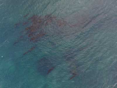
Minimize the Inclusion of Water
Always in motion, highly reflective, and transparent, water has a lot of properties that make it hard to render well.
Large areas of open water will not likely process well in any photogrammetric application. While it may turn out well enough in a 2D ortho map, water rarely renders
well in the 3D outputs and can add unsavory motion related artifacts. If you must include water in a survey area, try to keep some shore structure in place to give our processing something to hold on to.
Use LOTS of Overlap in Treed or Crop Areas
Trees are hard to render because they are typically almost always in motion and have a lot of fine detail.
Generally, the orthophoto portion of the processing
may turn out fine at 65-70% overlap. However, if there are trees included in survey area and you want the 3D components of the processing to turn
out well, we recommend using 80-90% overlap in order to make sure we have enough information to represent the trees properly. Bare trees are extremely hard to reconstruct well due to the complexity of the branches and shadows. Extra overlap should be used but even then it can be difficult. Also, avoid windy days when trees are involved.

Avoid Sun Glare and Highly Reflective Surfaces
You shouldn't stare into the sun and neither should your camera.
Even the best cameras have a limited range of brightness they can capture. When an area is too bright, it washes out all of the detail and makes that area lack the detail needed to reconstruct the scene.
The roofs of large buildings and wet pavement will often be too reflective to capture properly. This can be dealt with by mapping at least 1.5 hours off of solar noon in the summer during which time the sun will not be reflected directly into the camera or by utilizing a circular polarizing filter.

Use an Appropriate Camera
Cameras with a super wide field of view or a fisheye lens are not appropriate for mapping applications.
Large amounts of fisheye, or barrel distortion, give images a distorted pixel density which leads to inconsistent feature detection.
Our system will process images from these types of cameras but the outputs will be of low quality. Also, very low quality web cams, cell phone cameras and CMOS sensor modules are not of sufficient quality to be used for photogrammetry.

Avoid Overexposured and Underexposed Images
Properly exposed images provide Maps Made Easy with the detail needed to reconstruct the scene.
The white roofs of buildings and dark wooded areas are commonly the vicitims of exposure issues. These issues appear as swirly areas on the 2D maps and
spikes in the 3D models since there isn't enough consistent information for our system to do it's job. We recommend scouting the survey area ahead of time and doing some exposure
test images to determine the values that will work.

Minimize Constant Motion
The type of processing we use relies on detecting features of structures to derive its shape based on multiple looks.
If objects in the scene are moving, the processing gets confused and can generate positional errors.
In the case of a car on a road, as long as most of the looks don't have the car in the same location,
it won't be included. But in the case of coastal water which is always in motion, there will never be a structure static enough to be able to calcuate its position. Water is bad. Constant motion is bad.

Don't Fly Lower than 4-5 Times the Height of the Tallest Object in the Survey Area
The taller the object, the less overlap it will get.
Our processing is based on getting multiple looks at things. Multiple looks at things are attained through overlap. A tall object will
be viewed less often than an object on the ground and will likely have problems rendering. If the tallest object in your survey area is 10 meters,
fly at least 40 meters above ground. Flying with minimal clearances is not only dangerous, it will produce imagery with blocked areas and generate poor results.

Do Not Attempt to Stitch Vertical Surfaces
Maps Made Easy is intended for mapping horizontal surfaces.
We do not create spherical panoramas like some other companies do. We create maps. While some of the same priciples apply, our processing has been optimized to
perform well in an aerial mapping environment. Any data sets to not match this description should not be uploaded to our system because the outputs will not turn out and it will be a waste of resources.

Never Upload Images that Include the Horizon
Any image that includes the horizon should be kept out of your upload list.
Images that include the horizon will badly skew the results the system generates. Even if there may be a partial match with something our system sees on the ground the sky portion above the horizon could possibly be used
in texturing the 3D model and throw off the results for large areas of the map.
Only Nadir (Straight Down) Images Should be Used.
For creating orthophoto maps, all the images that go into processing it should be taken at, or near, nadir.
Any images that are taken more than 20 degrees off of straight down should be removed from the upload set. The goal of data
collection should be consistency. We understand that this can be hard with fixed wing aircraft, but there is a good chance
all images taken from a fixed camera system on a fixed wing aircraft that is making a banking turn will need to be removed. The
only exception to this is if you are planning on processing your data as Full 3D in which our system will make use of oblique images. Even in this case, no horizon view should be uploaded.

Avoid Dark Shadows
Avoid mapping late in the day when the sun is low and the shadows are long.
This scene is likely too dynamic for your camera to accurately capture. If the exposure time is set
to deal with the bright areas, the shaded areas will lack sufficient detail. If it adjusts for the darker areas, the light areas will be blown out and will also not have the detail required.
Shooting as close to the middle of the day fixes this problem and has the added benefit of keeping your exposure times short.

Other Considerations
- Never Fly Backwards or Sideways - Collect all of your data while traveling forward. Most aerial cameras have rolling shutters and mixing forward and backward flight ruins the chances of the job turning out well.
- Collect Images at a Consistent Speed - Images for a set should all be collected while traveling as close to the same speed as possible. With a rolling shutter, images taken at differing speeds will have different geometries and harm the accuracy of the final product.
- Avoid Aircraft Shadow Within Camera FOV - If the shadow of the aircraft can be seen in the images that means there will be a hotspot (travelling sunspot) in the images. This moving hotspot will cause processing to fail since the features will appear differently between successive images.
- Maximum Resolution - Take the size of your survey area and divide that by your GSD estimated GSD. If that is over 200k pixels in either direction you will need to break it up.
- Pre Processing - Images should not be processed to remove lens distortion. Color correction is OK but make sure the tags are intact.
- Overlap - The more, the better. (18-25 views of everything is good, 40 is too many) Along track and across track overlap should exceed 70%. More complex scenes require more overlap (80-83%).
- Exposure Time vs Speed - Try to keep your ground smear below the GSD value. 15 m/s flight at 1/1000s exposure will allow 1.5 cm GSD.
- File Naming and Numbering - All files that are uploaded must have unique file names. Files from multiple folders are OK but the names must still be unique. If you collect images on multiple SD cards or manage your own files you may have to rename some of the files to enforce this.
- One Camera, One Focal Length - Do not upload images that were taken on different cameras or with different focal lengths.
- Contiguous - All images must share a common boundary. Don't upload non connecting sections or separate islands of coverage.
- Job Shape - When doing long, linear jobs, make sure to do AT LEAST three passes so there are enough perspectives to reconstruct the scene. Increased overlap will need to be used to make up for the lost width. When doing few passes don't do a straight line. Either put a kink in it or use more passes.
- EXIF Tag Accuracy - Images should have geotag accuracy of less than 10 m and contain elevation values. Also, precision should be reported with at least 3 decimals of seconds precision. DD:MM:SS.SSS not DD:MM:SS.000.
- EXIF Tags Intact - EXIF tags should not be modifed by 3rd party image processing software. We need all the of the tags the camera originally places in the image files. Photoshop, Photos, Photo Manager and lots of other softwares have been known to corrupt the tags.
- Inclusion Area - Be sure to fly over areas that you want to be included in the map. We trim the jagged edges off and the best way to make sure something is included is to fly over it or make sure it is within the interior of your flight path.
- Repeating Patterns - Since our processing relies on matching similar features, target areas with repeating patterns such as roofs or crops can confuse the system and make poor quality outputs.
- Terrain - Terrain greatly affects overlap. If the terrain rises from your nominal overlap planning point it will be reduced. If the terrain drops from you planning point, it will be increased. Take the high point of your survey area into account.
- Weather Conditions - Clouds will affect the amount of light that is available and winds will affect the symmetry of your ground speed from pass to pass unless properly managed. Plan your flights accordingly.
- Avoid Early and Late in the Day - In addition to the increased presence of rapidly changing shadows, doing mapping flights during dusk or dawn hours will have less light available. Less light means longer exposure times which causes smearing.
- Avoid Solar Noon in Summer - See Aircraft Shadow above. Mapping 1.5-2 hours off of solar noon for your location will keep the sunspot out of your images. Solar noon is acceptable on overcast days as long as there is no shadow or in winter.
- Cruising Altitude Images Only - Only images taken at the cruising altitude should be uploaded into the system. Do not upload images from different altitudes like those taken during ascent and descent.
